The Myth of a World Reduced to One Map
Choose a world map projection for the question you need to answer, so comparisons of area, routes, and connections are clearer and less misleading.
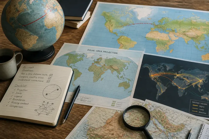
A world map projection can make Greenland look enormous, bend a flight path across the page, or split the Pacific at the edges. Each effect comes from how a curved planet is represented on a flat surface. To read a map well, start with the relationship you need to understand: area, direction, route, or connection.
Why can’t one world map show everything accurately?
A globe represents Earth’s curved surface. Flattening that surface changes some combination of area, shape, distance, and direction; no projection preserves all of them everywhere. A projection may keep local shapes recognizable while enlarging areas near the poles, or preserve relative area while making familiar outlines look unusual.
Scale creates a separate tradeoff. A map of the entire planet cannot show every street, coastline, and local feature clearly. Mapmakers simplify details so the features relevant to the map’s purpose remain legible.
Which projection fits the question?
Choose a projection by the relationship you want to inspect. An equal-area projection supports comparisons of relative land area. A Mercator map preserves local angles and can help with compass-direction navigation, but it greatly enlarges areas near the poles.
For a long-distance route, a globe makes the shortest surface path easier to see. An azimuthal map centered on the relevant region can also show that path clearly. On many flat maps, a great-circle route—the shortest path between two points on a sphere—appears curved. A compromise projection may suit a general wall map, but it does not preserve every property.
Look for a projection name and legend. If they are absent, avoid drawing strong conclusions from apparent size or straightness. Zooming or switching layers in a digital map can reveal different details, but it does not remove the projection’s distortions.
Why do countries look different in size?
On a Mercator map, places near the poles appear enlarged relative to places near the equator. Greenland can look comparable in size to Africa on the page, even though Africa covers much more land. Use an equal-area map to compare area, and remember that its outlines may look less familiar.
Imagine you need to explain why a classroom wall map makes Greenland look so large. You check its legend, identify the projection as Mercator, then compare the same regions on an equal-area map. The resulting explanation is specific: the first map helps preserve local shape and direction, while the second gives a fairer visual comparison of land area.
Why can a route that looks short take longer?
A line that looks short on a flat map may not be the shortest path over Earth’s surface. A great-circle route often bends on a flat projection. Actual journeys also depend on available transport links, weather, terrain, and access—details a basic world map may not show.
For a fictional trip between two cities on opposite sides of the North Atlantic, you might first draw a straight ruler line on a Mercator map. Next, trace the route on a globe and notice that the shortest surface path bends northward. Then check a route-planning map for available connections and constraints; the result is a clearer distinction between the shortest surface path and a practical journey.
How do network maps show connections?
A political or physical map emphasizes territory and landforms. A flow map emphasizes links, such as shipping lanes, airline routes, or data cables. Lines may be simplified, bundled, or varied in width, so read the legend before interpreting them.
A cluster of lines may show many routes, while a thicker line may indicate greater volume only if the map defines width that way. Check for direction, the period represented, and what kind of connection is counted. Network maps can reveal hubs and access, but they may hide geographic distance and the places between nodes.
What should I check before using a world map?
- Projection: Check the projection name. If it preserves the property your question concerns, use it for that comparison; otherwise, choose a more suitable projection.
- Scale: Check whether the view is global, regional, or local. If you need street-level detail from a global map, switch to a local map before making a decision.
- Legend: Check the meaning of colors, symbols, line widths, and units. If the legend defines them, interpret them accordingly; if it is missing, do not infer quantities from appearance alone.
- Boundaries: Check whether borders are dated, sourced, disputed, simplified, or omitted. If the map lacks that context and your question depends on a boundary, consult a source that provides it.
- Missing context: Check whether the map includes the terrain, routes, population, or other features your question requires. If not, add a map layer or use a different map before drawing a conclusion.
- Comparison: Check a second map with a different projection or purpose. If both show the feature you need in a comparable way, proceed cautiously; if they differ, identify the projection or selection choices behind the difference.
These checks matter when a map circulates online without its title, legend, or source. If you cannot recover those details, describe only what is visibly shown rather than treating the image as a complete account.
Which world map should I use for my question?
Which map is best for comparing country sizes?
Choose an equal-area projection because it keeps relative areas comparable, though outlines may look unfamiliar. Do not use apparent country size on a Mercator map as a direct area comparison.
Which map is best for planning a long-distance route?
Use a globe or a route tool that accounts for Earth’s curvature, then check a route layer for available connections and constraints. A line that looks shortest on a flat map may not be the shortest path over the surface.
Which map explains global trade or communication?
Look for a flow or network map with a clear legend, direction, and time period. Pair it with a geographic map when the location of the links matters too.
Can I compare maps made with different projections?
Yes, but first identify what each projection preserves. Compare area on an equal-area map and use a route-focused view for direction or travel paths instead of treating one visual feature as equivalent across both maps.
For a useful world map projection, name the question first: area, route, direction, or connection. Then select a map that supports that comparison and check its legend before acting on what you see. That habit helps separate a map’s useful signal from distortions introduced by its design.